Reprinted with permission from World at Large, a news website of nature, science, health, politics, and travel.
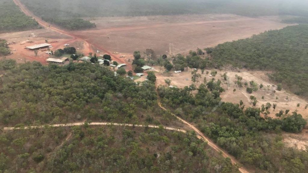
Two former cattle ‘stations’ in the north Australian state of Queensland totaling 509 square miles (131,900 hectares) have been purchased by the government as part of their program to return ownership of land on the Cape York Peninsula back to the indigenous people.
Environment Minister Meaghan Scanlon said at the time that these two areas have significant, undisturbed ecosystems that will become part of a protected area that includes tropical rainforest, heathlands, warm savannah, and freshwater ecosystems.
“These areas are important on a global scale both naturally and culturally, so it’s fantastic that they will be in safe hands as the Queensland government returns them back to the Wuthathi and Atambaya Peoples,” a spokesperson for Our Living Outback, an advocacy group, said at the time.
“This is one of the most significant purchases in Queensland history – linking close to one million hectares of protected land in a picturesque part of our state,” Annastacia Palaszczuk, the Queensland Premier said in a statement.
The two cattle stations link up with other protected areas, some under state control, others under Aboriginal control, including Batavia National Park, Ampulin National Park, Michingun Nature Refuge, and the Steve Irwin Wildlife Reserve, purchased by the Crocodile Hunter’s foundation set up by the Australia Zoo.
“The lands also provide further opportunity to protect the Great Barrier Reef by stabilizing two catchment areas that flow into the Great Barrier Reef lagoon,” Scanlon added. Cape York is known as the gateway to the Great Barrier Reef, but is incredible biodiverse in its own right.
RELATED: Australia Returns Huge Daintree Rainforest to its Aboriginal Owners, Bordering Great Barrier Reef

Righting Wrongs
These purchases are two of many that have been conducted under the Cape York Peninsula Tenure Resolution Program, which since 2007 has been restoring Aboriginal rights to some of the most biodiverse and valuable lands in the state.
By the end of 2021, before the recent cattle stations were acquired, the tenure program had already established 209 protected areas across 8.2% of all of the land space in Queensland (4.5 million hectares.) That’s about the size of Massachusetts and New Jersey together, or for Europeans, about Sicily, Belgium, and Crete combined.
It involved the transfer of control of 22 existing national parks to Aboriginal land holding entities, and managers of the program expect the 11 national parks on Cape York Peninsula which haven’t been, to be transferred over before long.
“Granting Aboriginal land and agreeing to the co-operative management of the national park is a positive step towards reconciliation by recognizing past Indigenous connection to the land,” said former-Minister for Natural Resources, Craig Wallace, after the first titles were given in 2008.
These protected areas are called National Park (Cape York Peninsula Aboriginal Land) or “CYPAL”. A CYPAL gives a “Freehold” title to the land. Normal Freehold Land means absolute ownership to do whatever the Aboriginal community pleases with it, but a Freehold title under CYPAL ensures the land remains managed as a national park.
Park management responsibilities will be negotiated between the department and the Traditional Owners (represented by a land trust) but will vary from park to park. Traditional Owners will be involved at every stage of management and obtain all the financial benefits that come from managing the land, whether that’s ecotourism, ranger employment, or any other kind of arrangement.

A stronghold for biodiversity
CYPALs make up some of the most biodiverse areas on the continent. Among these is the Daintree Rainforest, the oldest surviving rainforest on Earth. It contains 30% of the frog, reptile and marsupial species in Australia, and 90% her bat and butterfly species.
It also includes pine tree species that evolved in the Jurassic period, and ferns like Marattiaceae which evolved after the Devonian extinction, and Osmundaceae which predates the dinosaurs by an era; both of which are the only remaining families of the orders they belong to.
The geologic history is old, and part of Australia’s Great Dividing Range reaches up into the peninsula. Sandstone, limestone, schist, and dolomite coupled with the mountain range’s age means that erosion has dramatically shaped the landscape, creating features like Barron Gorge, Blencoe Gorge and Girringun, two areas within the Wet Tropics of Australia UNESCO World Heritage Site, and which are studded with dramatic waterfalls.
The range, which is not a continual range and actually a series of cordilleras, or broken up smaller ranges, also contains Wooroonooran, the highest mountain in Queensland, and an important bird area as designated by BirdLife International.
Wooroonooran contains a large population of the endangered southern cassowary, as well as prime habitat for most of the endemic bird species of the peninsula.
SHARE This Sharing of Land With Your Friends


